LINE A


The line A of the Rome metro , characterized by orange , was the second line to be built in the capital. The first section of the line, from Ottaviano to Cinecittà, was inaugurated on 16 February 1980 by the then mayor of Rome Luigi Petroselli, today the route extends from Battistini to Anagnina.

Today, line A has 27 stations (there are plans for extensions beyond the Battistini terminus) for a length of 18.425 km. Meet line B in Termini station and intersect, when operational, with line C in the stations of Ottaviano and San Giovanni.

MAP - LINE A

Featured

Rome metro card (includes also metro, bus, tram and Airport Bus from Ciampino)

(0)
Featured

City Pass Rome – 100% Mobile – Fast track entrance

(0)

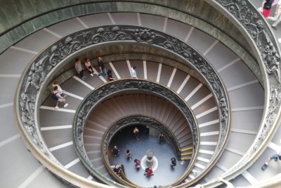
VATICAN MUSEUMS & SISTINE CHAPEL – Skip the line tickets

(0)

Line A (27 stations and 18.4 km) connects the west of Rome near the Vatican to the popular suburbs of the southeast. From the terminus of Battistini to that of Anagnina, the main stops are:


  • Ottaviano – San Pietro – Vatican Museums for Vatican Museums and St. Peter’s Basilica.
  • Flaminio for Piazza del Popolo and Villa Borghese Park.
  • Spagna serving the Spanish Square.
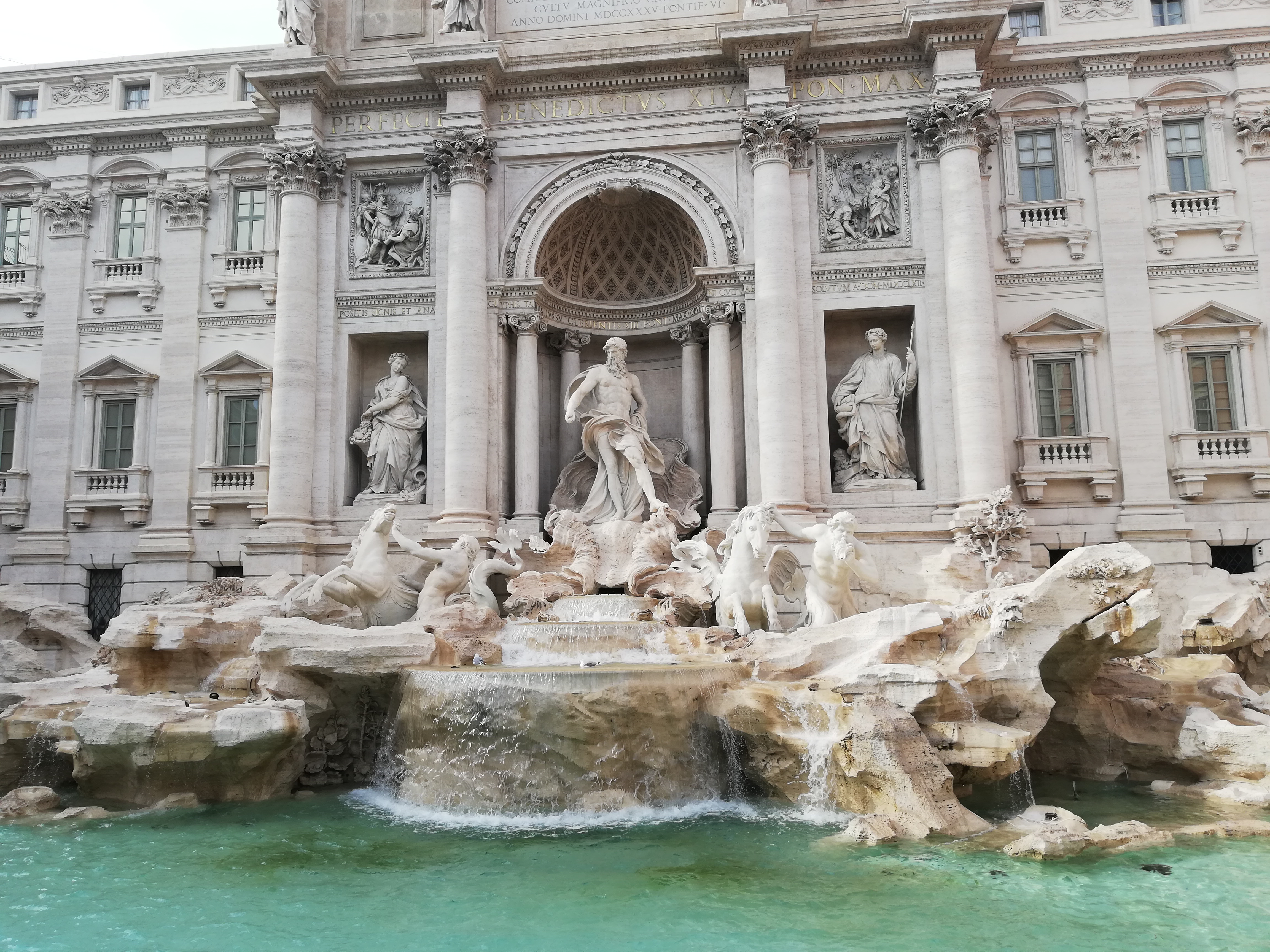
  • Barberini for the namesake square, Via Veneto and Trevi Fountain.
  • San Giovanni for the Basilica of St. John Lateran.
  • Cinecittà for the city of homonymous cinema.


The line is completely underground except for a bridge on the Tiber.

THE STATIONS OF LINE A:

  • The stations of line A of the Rome metro, where the respective stops are located, are the following:
  • Battistini
  • Cornelia
  • Baldo degli Ubaldi
  • Valle Aurelia
  • Cyprus
  • Ottaviano
  • Lepanto
  • Flaminio
  • Spain
  • Barberini (temporarily closed on 03/23/2019)
  • Republic (temporarily closed from 10/23/2018 to 06/26/2019)
  • Terms
  • Vittorio Emanuele
  • Manzoni
  • Saint John
  • King of Rome
  • Long Bridge
  • Furio Camillo
  • Colli Albani
  • Arch of Travertine
  • Porta Furba
  • Numidio Quadrato
  • Lucio Sestio
  • Giulio Agricola
  • Subaugusta
  • Cinecittà
  • Anagnina

THE CONSTRUCTION OF LINE A:

The construction works for the extension of the line were long and complex, mainly due to the technique of open excavation , which caused many problems to the viability of Rome. Precisely for this reason the works stopped for 5 years, before starting again with the technique, used today, of moles , which if on one hand solved the problem of traffic and traffic, on the other hand brought problems to the buildings placed above the route of the line.

Fermi for another two years, due to the crossing of the Tiber river, other problems resulted with an error in the route, due to the construction of the Nenni bridge for crossing the river, and for archaeological finds near Piazza della Repubblica.

2 Comments

  1. avatar
    Posted by J.J.A.M, van Groningen| 28 August 2019 |Reply

    Dear Madam , Sir,

    Which of the metro stations are accessible with a wheelchair.
    Best regards

    • avatar
      Posted by admin1175| 3 September 2019 |Reply

      Dear Madame, Sir ,

      Please find the informations below:
      ATAC Infoline: +39 0657003 (24 hours a day, every day, including holidays);
      Toll free number: +39 800 154451 (Monday-Saturday: 8.00 am – 8.00 pm);
      Web site: http://www.atac.roma.it/index.asp?p=109.
      The accessibility to the underground Metro system is the result of the continuous improvement of infrastructures, equipment and facilities:

      – On the A Line there are 39 trains in service with facilities for the disabled in wheelchairs, with loudspeaker stop alarms and automatic door opener systems;

      – B Line trains are equipped with rubber barriers to secure intra-carriage spaces;

      – 11 stops of the A Line, including the recently renovated Manzoni, are equipped with tactile paving and maps for the visually impaired, the remaining 15 stops with a stop code on the platforms, all elevators have Braille and raised numerals and voice announcements (Italian and English) of floor level.

      – All the B Line stops are equipped with tactile paving and maps for the visually impaired, elevators have Braille and raised numerals and voice announcements (Italian and English) of floor level, whereas stairlifts are installed in the three stations devoid of lifts.

      – All stations of the two lines will be upgraded to the standards of Manzoni station;

      – Accessibility and safety is being redeveloped in the Termini area.

      List of the metro stations providing access to people with physical disabilities or visual impairments:

      Linea A – Facilities
      Battistini – Elevators, tactile maps and paving
      Cornelia – Elevators, tactile maps and paving
      Baldo degli Ubaldi – Elevators, tactile maps and paving
      Valle Aurelia – Elevators, tactile maps and paving
      Cipro-Musei Vaticani – Elevators, tactile maps and paving
      Ottaviano–S. Pietro*
      Lepanto*
      Flaminio*
      Spagna*
      Barberini*
      Repubblica*
      Termini – Elevators, tactile maps and paving (works in progress)
      Vittorio Emanuele*
      Manzoni – Elevators, tactile maps and paving
      S. Giovanni*
      Re di Roma – Elevators, tactile maps and paving
      Ponte Lungo – Elevators, tactile maps and paving
      Furio Camillo – Elevators, tactile maps and paving
      Colli Albani*
      Arco di travertino*
      Porta Furba–Quadraro*
      Numidio Quadrato*
      Lucio Sestio*
      Giulio Agricola*
      Subaugusta – Elevators, tactile maps and paving
      Cinecittà – Elevators, tactile maps and paving
      Anagnina*

      Stazioni linea B – Facilities
      Rebibbia – Elevators, tactile maps and paving
      Ponte Mammolo – Elevators, tactile maps and paving
      S.M. del Soccorso – Elevators, tactile maps and paving
      Pietralata – Elevators, tactile maps and paving
      Monti Tiburtini – Elevators, tactile maps and paving
      Quintiliani – Elevators, tactile maps and paving
      Tiburtina – Elevators, tactile maps and paving
      Bologna – Elevators, tactile maps and paving
      Policlinico – Elevators, tactile maps and paving
      Castro Pretorio – Elevators, tactile maps and paving
      Termini** – Elevators, tactile maps and paving(works in progress)
      Cavour – Sairlifts, tactile maps and paving
      Colosseo – Stairlifts, tactile maps and paving
      Circo Massimo – Stairlifts, tactile maps and paving
      Piramide – Elevators, tactile maps and paving
      Garbatella – Elevators, tactile maps and paving
      Basilica S. Paolo – Elevators, tactile maps and paving
      Marconi – Elevators, tactile maps and paving
      Eur Magliana – Elevators, tactile maps and paving
      Eur Palasport – Elevators, tactile maps and paving
      Eur Fermi – Elevators, tactile maps and paving
      Laurentina – Elevators, tactile maps and paving

      * Stations without tactile paving, but with yellow truncated domes on platforms to alert people with vision impairments of their approach to hazardous drop-offs.

      ** The redevelopment of the Termini area was assigned after a competitive bid in July 2008.

Leave a Comment

Your email address will not be published. All fields are required.