LINE B
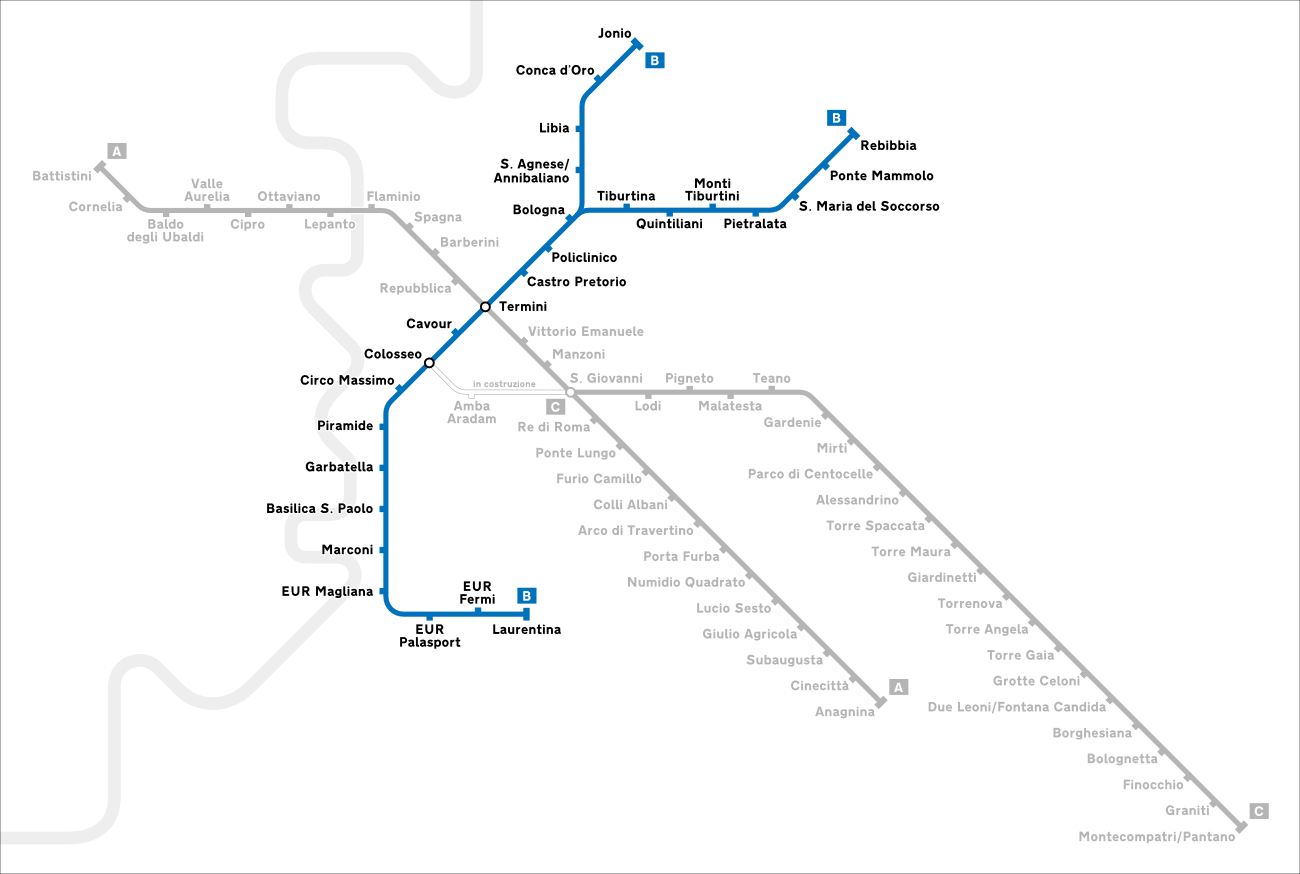
Line B of the Rome underground connects the city from south to north-east where it is divided into two branches: one to the east and one to the north-east. Its terminus is: Laurentina (in the Giuliano-Dalmata district), Rebibbia (in the Ponte Mammolo district, near the penitentiary of the same name), and Ionian (in the Monte Sacro district).
Rome’s metro B currently has 26 stations and an interchange with line A of the Rome metro (Termini station). It is characterized by the blue color , used for the decoration of trains and stations and for maps .
With 26 stations in total, Line B (23.1 km including 13 km underground) connects the Laurentina terminals south of Rome to Rebibbia and Jonio to the north. Two services are operated: from Laurentina to Rebibbia and vice versa, and from Laurentina to Jonio and vice versa.
MAP - LINE B

Rome metro card (includes also metro, bus, tram and Airport Bus from Ciampino)
Colosseum tickets – Fast lane – Incl. Videoguide tour
The main stops are:
- EUR Fermi, in the district built for the 1942 World’s Fair (EUR) that never took place.
- Basilica San Paolo serving the Basilica of St. Paul-off-the-walls.
- Garbatella for the Central Montemartini Museum.
- Piramide that gives access to Ostiense Station, Pyramid of Cestius and Testaccio.
- Circo Massimo (Circus Maximus) serving the FAO headquarters,
- Colosseo (Colosseum station).
- Tiburtina, for the suburban railway station of the same name.
- Ponte Mammolo for the bus station.
Total traffic is approximately 750,000 passengers per day on average. At peak times, service is provided by a train every 4 minutes.
THE STATIONS OF THE LINE B:
- Laurentina
- EUR Fermi
- EUR Palasport
- EUR Magliana
- Marconi
- Basilica of St. Paul
- Garbatella
- Pyramid
- Circus Maximus
- Coliseum
- Cavour
- Terms
- Castro Pretorio
- Policlinico
- Bologna
- Direction Rebibbia
- Tiburtina FS
- Quinitiliani
- Monti Tiburtini
- Pietralata
- Santa Maria del Soccorso
- Ponte Mammolo
- Rebibbia
- Ionian direction
- St. Agnes / Annibalian
- Libya
- Conca d’Oro
- Ionian
THE CONSTRUCTION OF LINE B:
The first subway line in Rome was designed and started in the thirties during the fascist regime, in order to offer a fast connection between the Termini station (located in the city center) and the new neighborhood called E42 (the current EUR), where the Universal Exposition of 1942 should have taken place.
For this reason the line should have been called E42 Railway. The technical characteristics, including the height of the sidewalks and the quays, were the same as those of the already existing Roma-Lido, of which the new underground line would have traced part of the route and shared electric traction and storage facilities.
However, the event never took place due to Italy’s entry into the war in 1940. At the time of the interruption of the works, some tunnels had already been built (in the section that goes from Termini to Piramide) which were used during the war. as air- raid shelters by the population of the city.Work on Rome’s metro B then resumed in 1948, simultaneously with the progress of the works in the former exhibition area which partially changed its appearance, destination (becoming a successful business district) and name (EUR, later Europe).
Line B of the Rome metro was finally inaugurated at the Termini station on 9 February 1955 by the President of the Republic Luigi Einaudi together with the Cardinal Vicar of Rome Clemente Micara. The following day the establishment was opened to the public.


